Urban Congestion in African Cities: 6 Critical Causes of Traffic Failure
Urban congestion in African cities is not a byproduct of prosperity. It is the outcome of six compounding structural failures: urbanisation outpacing road investment, radial road networks lacking bypass capacity, overreliance on unregulated paratransit, sprawling low-density land use, weak traffic enforcement, and chronic underinvestment in mass transit. Lagos loses commuters hours in daily gridlock, Cairo’s congestion drains billions from national output each year, and Nairobi’s road network still routes most cross-town traffic through a handful of colonial-era junctions.
Technical Snapshot: Urban Congestion Drivers at a Glance
| Driver | Metric |
| Africa’s urban population growth | Projected to double from 700 million to 1.4 billion by 2050 |
| Paratransit modal share, Sub-Saharan cities | 50 to 98 percent of motorised trips, averaging roughly 78 percent |
| Cairo’s annual congestion cost | Approximately $8 billion in lost productivity, fuel, and pollution |
| Cape Town’s global congestion rank | 6th most congested city worldwide, INRIX 2025 Global Traffic Scorecard |
| Africa’s annual infrastructure financing gap | Estimated at $130 billion a year |
| Nairobi’s dominant public transport mode | Matatus, carrying an estimated 40 to 50 percent of all trips |
Understanding these six drivers matters because every megaproject, BRT corridor, and ring road proposal in Africa is ultimately a response to one or more of them. Getting the diagnosis right and correctly identifying the causes of traffic congestion behind a given corridor is the difference between infrastructure that relieves urban congestion in African cities and infrastructure that simply relocates the bottleneck.
Introduction: Urban Congestion in African Cities
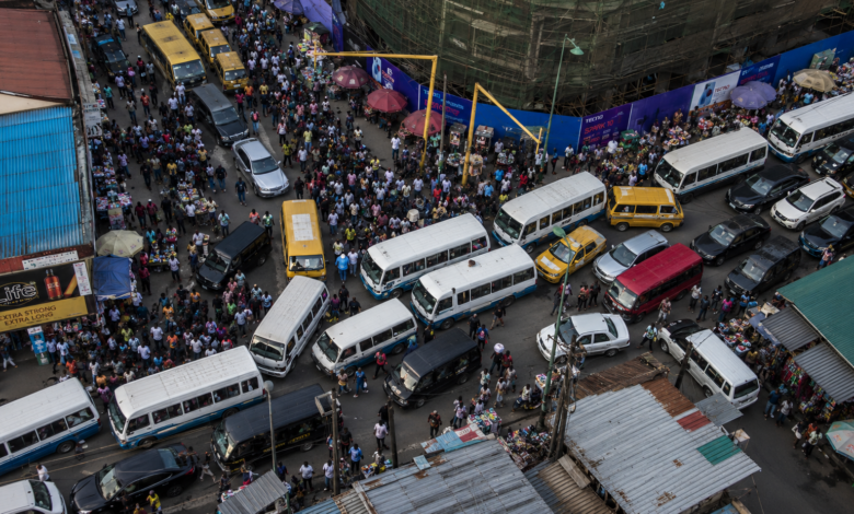
Drive through Lagos at 7 am, Nairobi at 5 pm, or Cairo on any weekday, and the pattern repeats: bumper-to-bumper traffic stretching for kilometres, commutes measured in hours rather than minutes, and a road network visibly straining under demand it was never designed to carry. Urban congestion in African cities has become one of the defining infrastructure challenges of the continent’s growth story, and it is worsening even as governments pour billions into new roads, flyovers, and expressways.
The reason new asphalt alone rarely fixes the problem is that traffic congestion in Africa is rarely caused by a single failure. It is the product of overlapping structural weaknesses: demographic growth that road planners never modelled for, networks designed around a handful of radial corridors, informal transit systems operating with no route discipline, land use patterns that force long commutes, enforcement capacity too thin to manage the traffic that exists, and mass transit investment that has lagged decades behind demand.
Reforms such as the design principles guiding African BRT corridors tackle pieces of this puzzle, but understanding why African cities’ traffic crisis exists in the first place is the necessary starting point for any credible fix. This article breaks down the six structural causes behind urban mobility failure across the continent’s fastest-growing cities, and the metrics engineers and planners use to measure just how severe the problem has become.
Rapid Urbanisation Outpacing Infrastructure Investment
Africa is urbanising faster than any other region on earth, and its road networks have not kept pace. This mismatch between population growth and infrastructure delivery is the root cause of urban congestion in African cities and shapes every other factor discussed in this article.
Population Growth vs Road Network Expansion
Africa’s urban population is projected to double from roughly 700 million to 1.4 billion by 2050, making it the second-largest urban population bloc after Asia. Cities with over one million residents currently number around 60 across the continent; that figure is expected to rise to 159 by mid-century. Transport infrastructure in Africa, by contrast, expands at a fraction of that pace. Most African capitals built their primary arterial roads decades ago, when populations sat at a tenth of current levels, and subsequent expansion has been incremental rather than structural.
The result is a widening capacity gap. A road corridor engineered in the 1970s or 1980s for a city of half a million residents now serves a metropolitan area ten times that size, with vehicle ownership climbing in parallel. The African Union estimates the continent’s overall infrastructure financing gap at approximately $130 billion annually, and transport accounts for a disproportionate share of that shortfall because road construction is capital-intensive and politically slow to deliver compared with the pace of urban growth.
Informal Settlement Growth and Transport Access
Rapid urbanisation in Africa has not been evenly distributed. A large share of new urban residents settle in informal or semi-formal areas that grew without any accompanying road, drainage, or transit planning. In Sub-Saharan Africa, over half of the urban population lived in informal settlements as of the most recent comprehensive estimates, and that share continues to climb in cities absorbing the fastest population growth.
These settlements are typically dense, laid out along footpaths rather than vehicle-scale streets, and disconnected from the formal road grid. Residents depend almost entirely on paratransit or long walks to reach a road wide enough for a bus or matatu, adding to the load on the few formal corridors that do exist. Structural causes of urban congestion in Africa cannot be separated from this settlement pattern, and the resulting urban transport failure in Africa is as much about access as it is about capacity: a road-widening scheme downtown does nothing for a commuter who first has to walk 40 minutes just to reach a paved road.
Road Network Design and Capacity Constraints
Even where roads exist, their layout often works against efficient traffic flow. Many African capitals inherited colonial-era road geometries designed to connect an administrative core to outlying residential areas, not to move large volumes of cross-town traffic. That legacy geometry is now one of the clearest transport-planning failures in African cities, and it explains why urban congestion persists even along corridors that have been widened repeatedly.
Radial Road Networks and Bottleneck Effects
Cities such as Nairobi, Lagos, and Accra rely heavily on radial road networks, corridors that fan outward from a central business district rather than forming an interconnected grid or ring structure. Radial networks concentrate traffic onto a small number of routes at the points closest to the centre, creating severe bottlenecks at key junctions regardless of how many lanes exist further out. Nairobi’s road system illustrates this well: nearly every major route into the city converges on a handful of roundabouts and interchanges near the central business district, so peak-hour demand overwhelms those pinch points long before the network reaches capacity.
This is why widening a single corridor rarely solves traffic gridlock and urban congestion in African cities on its own and why urban congestion so often reappears within months of a widening project’s completion. Adding lanes to a radial route increases the volume of vehicles arriving at the bottleneck without adding any capacity to disperse them once they get there. Planners increasingly recognise that congestion in radial systems needs to be addressed at the junction and network level, not the corridor level.
Missing Ring Roads and Bypass Infrastructure
The structural fix for radial bottlenecks, a ring road or bypass system that lets through-traffic avoid the city centre entirely, remains incomplete or absent in most African capitals. Nairobi’s outer ring road network exists only in partial form; Lagos has no continuous ring road connecting its mainland and island districts; Accra’s bypass infrastructure covers only a fraction of the metropolitan area. Where ring roads have been built, as in parts of Addis Ababa and Cairo, congestion indices in the corridors they relieve have measurably improved, underscoring how much of the current burden stems simply from missing infrastructure rather than mismanagement.
Building ring roads is expensive and politically unattractive compared with visible city-centre interventions, since the benefits accrue gradually and are harder to attribute to a single administration. That incentive mismatch, more than any single technical constraint, is a textbook case of poor urban traffic planning in Africa: it helps explain why so many African cities have deferred bypass construction even as congestion has worsened year over year.
Road Network Typologies and Congestion Effects
| Network Type | Typical Congestion Pattern | Example Cities |
| Radial, no ring road | Severe bottlenecking at central junctions; through-traffic forced into the core | Nairobi, Lagos, Accra |
| Radial with partial ring road | Reduced but uneven relief; congestion shifts to ring-road junctions | Nairobi (outer sections), Kampala |
| Radial with a complete ring road | Through-traffic bypasses the core; central congestion is measurably lower | Addis Ababa, Cairo (Ring Road) |
| Grid-based network | Load is distributed across multiple parallel routes; fewer single points of failure | Johannesburg CBD, Casablanca |
Dominance of Informal and Paratransit Systems
No discussion of why African cities have traffic congestion is complete without addressing paratransit. Minibuses, shared taxis, and motorcycle taxis carry the overwhelming majority of urban trips across the continent, and the way they operate directly and measurably affects road capacity and traffic flow. Paratransit dominance is, on its own, one of the most cited causes of traffic and urban congestion in African cities, and it interacts with nearly every other cause on this list.
Matatus, Danfos, and Trotros as De Facto Transit
Paratransit vehicles, known locally as ‘matatus’ in Kenya, ‘danfos’ in Nigeria, ‘trotros’ in Ghana, ‘daladalas’ in Tanzania, and by similar names elsewhere, account for an estimated 50 to 98 percent of motorised trips in Sub-Saharan African cities, with an average of roughly 78 percent. In Nairobi specifically, matatus are estimated to carry 40 to 50 percent of all trips across the city, well ahead of private cars or formal public transport. These vehicles function as the de facto backbone of urban mobility in the near-total absence of state-run alternatives, a reality Nairobi is now testing directly through its plan to adapt Colombia’s TransMilenio BRT model to a paratransit-dominated market.
Paratransit Naming and Modal Share by Country
| Country | Local Name | Estimated Modal Share |
| Kenya | Matatu | ~40 to 50 percent of trips (Nairobi) |
| Nigeria | Danfo | Up to 80 percent of motorised trips (national estimate) |
| Ghana | Trotro | Dominant mode; part of the ~78 percent regional average |
| Tanzania | Daladala | Dominant mode; part of the ~78 percent regional average |
| South Africa | Combi/minibus taxi | Dominant mode across major metros |
The scale of paratransit dependence means that its operating patterns are not a peripheral issue; they are central to how urban congestion in African cities functions day to day. Minibuses stopping anywhere along a route to pick up or drop off passengers, weaving between lanes to reach waiting riders first, and clustering at informal terminals with no dedicated bays all reduce effective road capacity well below what the same corridor could carry under regulated operations.
Lack of Route Regulation and Scheduling
Most paratransit systems operate without fixed schedules, designated stops, or enforced route discipline. Drivers are typically paid per trip or per passenger rather than a wage, creating a strong incentive to maximise trip volume through aggressive driving, informal stops, and route deviations, all of which degrade traffic flow for other road users. Attempts to formalise these systems through licensing, SACCO-style cooperative structures, or integration into BRT corridors have made uneven progress, often stalling on the same political barriers that undermine formalisation efforts elsewhere and that BRT projects in Africa face.
The absence of regulation is not simply an oversight; it reflects that paratransit fills a genuine gap left by underfunded formal transit, and operators have little incentive to accept discipline that could reduce their earnings in the absence of a credible alternative source of income. Any structural solution to urban mobility failure has to account for this economic reality rather than treating informal operators purely as an enforcement problem.
Further Reading: BRT Governance in Africa: 5 Political Barriers to Project Success
Land Use and Urban Sprawl Patterns
How African cities grow physically compounds the effects of every other cause on this list. Land use planning, or the lack of it, determines how far people must travel, how many trips they need to take, and how easily those trips can be served by anything other than a private vehicle. Left unaddressed, this pattern locks urban congestion in African cities into the built form of the city itself, and it is one of the structural causes of urban congestion in Africa that no amount of road or transit investment alone can undo.
Mixed-Use Zoning Deficits
Many African cities retain zoning frameworks that separate residential, commercial, and industrial land uses into distinct districts, a pattern often inherited from colonial-era master plans designed around segregation rather than efficiency. This separation forces residents into long, single-purpose commutes between home and work, rather than allowing daily needs to be met within a short radius. Mixed-use development, where offices, shops, and housing are within walking distance of one another, remains the exception rather than the rule in most African metropolitan areas, even in newer developments built well after independence.
The practical consequence is that trip volumes stay high regardless of how efficient the transport network becomes, because urban form itself generates unnecessary travel demand. Poor urban traffic planning in Africa is as much a land-use failure as a road-engineering one, and no amount of BRT or ring-road investment can fully compensate for a city where every daily errand requires a motorised trip.
Peripheral Development and Long Commutes
Rising land prices near urban centres have pushed new housing development to city peripheries, often 20 to 40 kilometres from major employment districts, while jobs remain concentrated downtown. This peripheral growth pattern, common in Lagos, Nairobi, Accra, and Johannesburg, extends average commute distances well beyond what existing transport infrastructure was designed to serve. Long commutes also reinforce dependence on private vehicles, since paratransit and bus services rarely cover peripheral routes with the frequency or reliability that a multi-hour daily commute demands.
This sprawl compounds the barriers that keep African commuters locked into private vehicle use rather than shared or mass transit. Breaking the cycle requires coordinated land use and transport planning, something few African cities have institutional structures in place to deliver, since urban planning authorities and transport agencies frequently operate under separate mandates with limited coordination.
Further Reading: Public Transport vs Private Vehicles: 4 Barriers to Shifting Mobility
Weak Traffic Management and Enforcement
Even a well-designed road network underperforms if the traffic moving through it is poorly managed. Signal timing, intersection geometry, and enforcement capacity all shape the throughput a given corridor can deliver, independent of its physical dimensions. Weak enforcement alone will not explain African cities’ traffic crisis, but, combined with the other five drivers, it consistently turns manageable traffic congestion into full gridlock during peak hours.
Signal Timing and Intersection Design
Many African cities operate traffic signals on fixed timing plans set years or decades earlier, with no adaptive control that responds to real-time traffic volumes. Roundabouts, common in cities with British colonial road heritage such as Nairobi and Accra, become severe bottlenecks once traffic volumes exceed their design capacity, since they lack the directional priority that signalised intersections can provide. Retrofitting these junctions with signals, grade separation, or adaptive traffic control systems has proven effective where implemented, but coverage remains patchy and concentrated in a small number of high-visibility corridors.
Intersection design failures compound quickly across a network. A single poorly timed junction can create queues that back up for several kilometres during peak hours, turning what should be a localised delay into city-wide gridlock.
Enforcement Capacity and Compliance
Traffic police forces across most African cities are understaffed relative to vehicle volumes, and enforcement of lane discipline, parking restrictions, and route compliance is inconsistent at best. Illegal parking narrows the effective road width on major corridors, unauthorised stops by paratransit vehicles disrupt traffic flow at unpredictable points, and weak enforcement of vehicle roadworthiness standards further increases unpredictability through breakdowns and low-speed vehicles mixing with fast-moving traffic.
Technology-assisted enforcement, CCTV monitoring, automated fine systems, and centralised traffic control centres have begun appearing in cities such as Kigali and Cairo, with measurable reductions in violation rates where deployed. But the upfront capital costs and ongoing institutional capacity required to run these systems put them out of reach for many city governments that are still struggling to fund basic road maintenance.
Underinvestment in Mass Transit Alternatives
Perhaps the clearest structural driver of urban congestion in African cities, and arguably the single largest contributor to urban transport failure in Africa, is the sheer scale of underinvestment in formal mass transit relative to road spending. Transport infrastructure in Africa has, for decades, been planned and budgeted as if roads and transit were substitutes rather than complements. Where cities have built rail or BRT capacity, congestion metrics have improved measurably along served corridors; where they have not, private vehicle and paratransit volumes continue to absorb all available road capacity.
Rail and BRT Coverage Gaps
Very few African cities operate rail-based mass transit at a scale proportional to their population. Lagos’s blue line and Addis Ababa’s light rail stand out as exceptions rather than the norm, and even these systems cover only a fraction of daily trip demand across their respective metropolitan areas. BRT coverage is more widespread but still limited: Cape Town’s MyCiTi network, one of the continent’s most developed BRT systems, remains concentrated in the central city and on the Atlantic Seaboard, leaving most residents dependent on private cars or minibuses for their daily commutes.
Mass Transit Coverage, Selected African Cities
| City | Rail-Based Transit | BRT Coverage |
| Lagos | Blue Line light rail (partial network) | Limited; expansion underway |
| Addis Ababa | Light rail network, city-wide | Not the primary mode |
| Cape Town | Metrorail (legacy, limited reliability) | MyCiTi: central city and Atlantic Seaboard only |
| Nairobi | Commuter rail, limited coverage | Corridors under construction, not yet operational city-wide |
| Cairo | Metro, the most extensive in Africa | Limited BRT presence |
Cities connecting BRT and rail into a single integrated system, rather than running isolated corridors that compete for the same limited ridership, offer the clearest template for what genuine mass transit integration requires in practice.
Budget Allocation Between Roads and Transit
National and municipal transport budgets across Africa remain heavily skewed toward road construction and maintenance rather than mass transit. Roads are politically visible, faster to deliver within an election cycle, and easier to fund through conventional infrastructure loans than transit systems, which require more complex financing structures and longer payback horizons. The financing challenge is not simply a matter of insufficient capital; it is a matter of structuring funding strategies for BRT systems in Africa that make transit bankable in markets where fare revenue alone rarely covers operating costs.
This imbalance is self-reinforcing, leading to urban congestion in African cities. Every kilometre of new road built without matching transit investment increases the private vehicle and paratransit volumes that future transit systems will need to absorb, making the transition more expensive and disruptive than it would have been if transit had been prioritised earlier.
Diagnosing Congestion: Metrics and Benchmarks Engineers Use
Fixing urban congestion in African cities starts with measuring it accurately, and the profession relies on a handful of standard metrics to isolate the specific causes of traffic congestion on a given corridor and track whether interventions are actually working.
Congestion Index Comparisons Across African Cities
The INRIX Global Traffic Scorecard remains the most widely cited benchmark for cross-city comparison. In its 2025 edition, Cape Town ranked as the sixth most congested city worldwide, with congestion levels rising 16 percent since 2023 despite only a 2 percent year-on-year increase, indicating a sustained structural trend rather than a short-term spike.
Johannesburg ranked 29th globally, with motorists losing an average of 59 hours annually to traffic delays. Cairo’s congestion has been estimated to cost the Egyptian economy approximately $8 billion a year in lost productivity, additional fuel consumption, and pollution-related impacts, a figure consistent with the broader pattern of urban gridlock’s drain on GDP across African economies documented elsewhere on the continent.
Traffic Congestion Index, Selected African Cities
| City | Traffic/Congestion Index | Notable Metric |
| Cape Town | 6th most congested globally (INRIX 2025) | Congestion up 16% since 2023 |
| Johannesburg | 29th most congested globally (INRIX 2025) | 59 hours lost annually per motorist |
| Casablanca | Traffic Index 181.0 | Moderate to high congestion |
| Tunis | Traffic Index 153.8 | Average commute: 37 minutes |
| Cairo | Not INRIX-ranked; independent World Bank estimate | ~$8 billion annual productivity loss |
These indices matter beyond bragging rights. City administrations increasingly use them to benchmark the effectiveness of specific interventions, comparing congestion trends before and after a BRT corridor opens or a ring road segment is completed, giving planners a defensible, data-driven basis for prioritising which projects to fund next.
Further Reading: Traffic Congestion Economics: 5 Ways Urban Gridlock Hurts GDP
Vehicle-to-Road Capacity Ratios
Vehicle-to-capacity (V/C) ratios, the volume of vehicles attempting to use a road segment divided by the maximum volume that segment can theoretically carry at free-flow speed, give engineers a more granular, corridor-level view than city-wide indices. A V/C ratio above 0.85 typically indicates unstable flow conditions where minor disruptions, a stalled vehicle, or an unauthorised stop, cause disproportionate delay; ratios above 1.0 indicate the corridor is operating beyond its designed capacity for sustained periods, which describes peak-hour conditions on most primary arterials in Lagos, Nairobi, Cairo, and Accra.
Tracking V/C ratios over time lets planners identify which specific junctions or corridor segments are driving city-wide congestion, rather than treating an entire road network as uniformly overloaded. This granularity is what distinguishes a credible transport masterplan from a generic call for more roads, and it is increasingly the standard against which donor-funded transport projects are evaluated before financing is approved.
Conclusion: Breaking the Congestion Cycle
Traffic gridlock and urban congestion in African cities will not be solved by any single intervention because they are not caused by a single failure. Anyone asking why African cities have traffic congestion needs to look at all six drivers together: rapid urbanisation, radial road geometry, paratransit dominance, sprawling land use, weak enforcement, and underfunded mass transit reinforce each other in a cycle that has proven remarkably resistant to piecemeal fixes. A new flyover relieves one bottleneck while doing nothing for the settlement pattern that generates excess trip demand in the first place. A new BRT corridor moves passengers efficiently along its own alignment while leaving the radial network around it just as congested as before.
Breaking that cycle requires treating these six causes as a connected system rather than a checklist of unrelated problems. Cities that have made genuine progress, like Cape Town’s MyCiTi expansion, Addis Ababa’s light rail and ring road combination, and Kigali’s traffic technology rollout, have done so by pairing infrastructure investment with land use reform, paratransit integration, and sustained enforcement capacity, not by relying on any one of those levers alone. The cities that continue to treat congestion as purely a road-building problem will keep building their way into the same gridlock, just with wider lanes.
Solve Urban Congestion With Proven Transport Insights
Explore more technical transport infrastructure analyses, urban mobility reviews, and traffic engineering deep dives on Construction Frontier: Urban Infrastructure & Transportation Systems, where congestion challenges, public transport systems, transport planning, and proven engineering solutions for African cities are examined through practical civil engineering insight.