Eysturoy Tunnel: The Bold Engineering Breakthrough Behind the World’s First Undersea Roundabout
The Eysturoy Tunnel (Eysturoyartunnilin) is an 11.24-kilometre subsea road tunnel network in the Faroe Islands, connecting the island of Streymoy to Eysturoy beneath the North Atlantic Ocean. Opened on 19 December 2020 after four years of construction, the Faroe Islands subsea tunnel reaches a maximum depth of 189 metres below sea level and carries approximately 6,386 vehicles per day. It is the largest infrastructure project in Faroese history and holds a Guinness World Record as the world’s first undersea roundabout.
Technical Snapshot: Eysturoy Tunnel Core Project Specifications
| Specification | Detail |
| Full Name | Eysturoyartunnilin (Eysturoy Tunnel) |
| Total Network Length | 11,238 m (11.24 km / 6.98 miles) |
| Maximum Depth Below Sea Level | 189 m (620 ft) |
| Roundabout Depth Below Sea Surface | 72.6 m (238 ft) |
| Tunnel Profile | Norwegian T10.5: 10.5 m wide, 4.6 m clearance, 82 m2 cross-section |
| No. of Lanes | 2 (bidirectional) |
| Operating Speed | 80 km/h |
| Network Branches | 3 (Y-shaped: Hvitanes, Strendur, Saltnes/Runavik) |
| Construction Method | Drill-and-blast in basalt bedrock |
| Drilling Equipment | Two Atlas Copco XE3 jumbos |
| Contractor | NCC (Nordic Construction Company, Sweden) |
| Owner/Operator | P/F Eystur- og Sandoyartunlar (EStunlar) |
| Construction Start | February 2017 |
| Opened to Traffic | 19 December 2020 |
| Grout Used | Approximately 7,500 tonnes |
| Construction Cost (Eysturoy component) | Approx. 1 billion DKK |
| Combined Contract (Eysturoy + Sandoy) | 2,073 million DKK |
| Daily Traffic (2025) | 6,386 vehicles/day |
| World Record | First undersea roundabout (Guinness World Records, 2020) |
The Eysturoy Tunnel redefined what small-island infrastructure can achieve. As the third Faroe Islands subsea tunnel and the first in the world to incorporate a submerged traffic junction beneath the Atlantic, it replaced a journey of over one hour with a 16-minute drive, demonstrating that political will and engineering precision can overcome North Atlantic depths.
Introduction: The Tunnel That Rewired an Archipelago
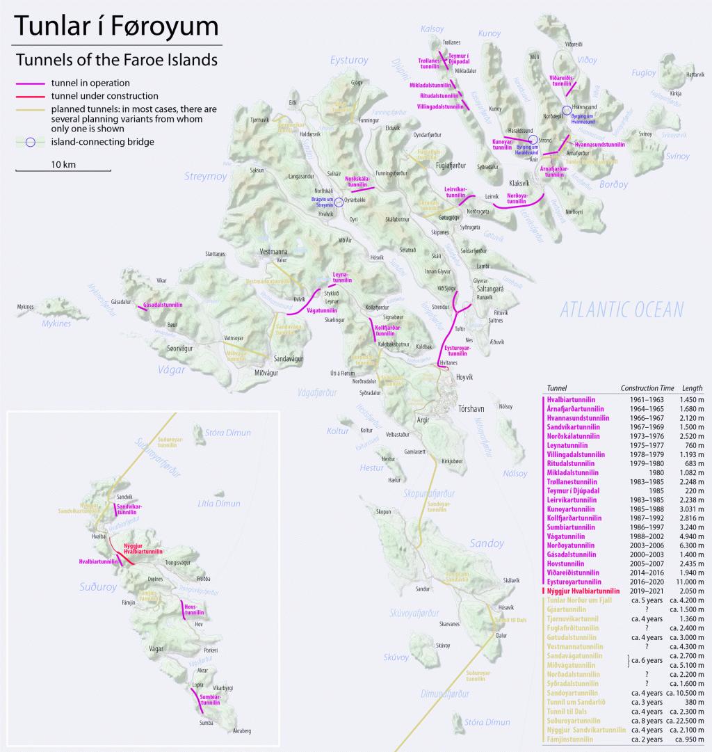
The Eysturoy Tunnel emerged from necessity, not abundance. The Faroe Islands, an 18-island North Atlantic archipelago of roughly 54,000 people, spent decades converting sea crossings into road connections, and the Eysturoyartunnilin, which Faroe Islands authorities approved in 2014, is the apex of that programme. It is the first tunnel anywhere on earth to incorporate a functioning roundabout beneath the seabed, a Faroe Islands subsea tunnel that plunges to 189 metres below sea level across three branches spanning 11,238 metres.
Amongst the wider class of ambitious fixed-link crossings examined by Construction Frontier in undersea tunnel engineering, the Eysturoy Tunnel stands apart: not for its scale but for solving a three-way subsea junction that no prior project had attempted. This article covers the geology, drill-and-blast construction method, roundabout engineering, and economic impact behind the Eysturoy Tunnel, drawing on verified project data from the contractor NCC, operator EStunlar, and Norwegian subsea tunnel design standards.
Project Context and the Faroese Tunnel Network
The Eysturoy Tunnel sits inside a larger strategic picture. The Faroe Islands had already demonstrated the economic transformative power of subsea tunnels: the Vagatunnilin opened in 2002, linking Vagar and Streymoy, and the Nordoyatunnilin followed in 2006, connecting Eysturoy to the northern island of Bordoy. Each tunnel converted ferry-dependent communities into road-connected ones, compressing hours of travel into minutes and integrating labour markets across island boundaries. The appetite for more was clear, and the Eysturoyartunnilin, in the Faroe Islands, which authorities eventually approved in 2014, was the most ambitious undertaking in that programme.
Parliamentary approval came after a political crisis that had derailed earlier private-sector proposals. A 2013 attempt to structure the project as a private concession unravelled after undisclosed arrangements between the Faroese transport minister and Copenhagen Infrastructure Partners became public. The minister resigned, and the subsequent inquiry forced early elections. Out of that crisis came a cleaner model: a public company, P/F Eystur- og Sandoyartunlar (EStunlar), wholly owned by the Ministry of Transport, would build, own, and operate both the Eysturoy Tunnel and the forthcoming Sandoyartunnilin.
1. Route Design and Junction Logic
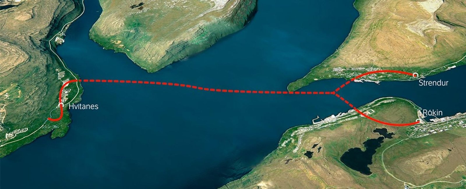
The tunnel’s Y-shaped geometry was deliberate. One arm connects south to Hvitanes on Streymoy, providing direct access to the capital, Torshavn. The other two arms split northward to serve Strendur on the western bank of Skalafjoerdur and Saltnes near Runavik on the eastern bank. These two eastern portals sit on opposite sides of the same fjord. Before the tunnel opened, travelling between them required a 25-kilometre road circuit. The Eysturoy Tunnel reduces that distance to 5 kilometres. The junction of all three arms, the undersea roundabout that Faroe Islands drivers now navigate daily, sits at 72.6 metres below the sea surface, directly beneath the mouth of the Skalafjoerdur fjord.
The combined travel-time reductions are significant. Torshavn to Runavik dropped from 64 minutes to 16 minutes. Torshavn to Klaksvik, the islands’ second city, fell from approximately 68 minutes to 35 minutes after the Faroe Islands subsea tunnel opened. Travel between Strendur and Runavik shifted from a 25-kilometre circuit to a 5-kilometre tunnel. These reductions are not marginal. For a population of 54,000, they represent a structural reorganisation of daily mobility.
2. Financing and Cross-Subsidisation
The financial architecture departs from the model used for earlier Faroese tunnels. EStunlar cross-subsidises the Sandoyartunnilin using surplus revenues from the Eysturoy Tunnel. The Sandoy route crosses 22 kilometres of open water and was projected to carry only 310 vehicles per day, generating insufficient toll revenue to repay its construction costs independently. The Eysturoy Tunnel, by contrast, serves the two most populous islands and generates substantially higher traffic volumes. Tolls on the Eysturoy route are therefore fixed at a level that covers both tunnels’ debt, rather than being allowed to fall as traffic grows. Motorists pay approximately USD 25 per crossing, or USD 10 with an annual pass, with number-plate recognition cameras automating collection.
Geology, Site Conditions, and Subsea Challenges
Understanding the Eysturoy Tunnel requires understanding what lies beneath the Tangafjoerdur Fjord. The Faroe Islands are entirely volcanic. Over millions of years, successive lava flows built a basalt platform up to six kilometres thick. The rock that NCC encountered in the Eysturoyartunnilin is primarily middle basalt, the dominant formation across most Faroese tunnel routes, characterised by high compressive strength and relatively predictable drilling behaviour.
1. Basalt Bedrock and Structural Behaviour
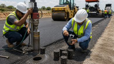
Basalt’s compressive strength makes it well-suited to drill-and-blast excavation: the rock fractures cleanly under controlled detonation, and the excavated face holds its shape long enough for immediate support to be applied. NCC adopted the standard Norwegian T10.5 tunnel profile for the Eysturoy Tunnel: 82 square metres in cross-section and 10.5 metres wide at road level, consistent with Norwegian Public Roads Administration (NPRA) subsea tunnel design standards. This profile accommodates two traffic lanes, emergency lay-bys, drainage infrastructure, and cable trays within a single-tube bidirectional bore.
Basalt’s homogeneity is never guaranteed across a full alignment. Interbedded lava flows produce internal contacts (zones where one flow cooled against another), creating weaker, more permeable planes. Dyke intrusions add further complexity: vertical igneous features that cut across bedding and can carry groundwater under pressure. The Eysturoy route encountered both conditions, and it drove one of the project’s most significant construction challenges. Eysturoy Tunnel length, depth, and construction facts must therefore include the grouting response, not just the excavation statistics.
2. Grouting Demands at Depth
Pre-excavation grouting is standard practice in Norwegian subsea tunnel design. Before each blast advance, grout is injected ahead of the tunnel face through a fan of drill holes, sealing discontinuities and reducing groundwater inflow to manageable levels. On the Eysturoy Tunnel, the grouting demand substantially exceeded original estimates. NCC project manager Alf Helge Tollefsen confirmed that approximately 7,500 tonnes of grout were consumed across the Eysturoy route, considerably more than the two earlier Faroese subsea tunnels required combined.
One zone of particularly poor rock quality required intensive treatment, with the advance rate slowing and multiple grouting cycles applied before blasting could resume. This added cost and time to the schedule but preserved the watertight integrity that a 189-metre-deep submerged traffic junction beneath the Atlantic demands.
The roundabout cavern required systematic grouting throughout its excavation. Structurally, it is the most complex point in the network: three tunnel bores converge into a single enlarged chamber, and the rock above carries the full hydrostatic load of the fjord. Every blast in the roundabout section was executed in smaller increments, with immediate rock bolting and shotcrete application after each round. Wire mesh reinforcement backed the shotcrete lining across the full excavated perimeter.
Table 1: Principal Geotechnical Challenges and Engineering Responses
| Challenge | Engineering Response | Outcome |
| Higher-than-expected groundwater inflow | Systematic pre-excavation fan grouting ahead of the tunnel face | 7,500 tonnes of grout consumed; watertight alignment achieved |
| Zone of poor-quality fractured basalt | Reduced blast round lengths; immediate rock bolt and shotcrete installation | Structural integrity maintained; schedule extended by weeks |
| Roundabout cavern (three-way junction) | Full-perimeter systematic grouting; smaller blast increments; wire mesh and shotcrete | Junction chamber excavated safely; natural basalt column retained as centrepiece |
| 189 m depth hydrostatic pressure | Norwegian T10.5 profile with continuous drainage; pump infrastructure at low points | No recorded water ingress incidents post-commissioning |
| Spoil disposal (approx. 1 million m³ excavated rock) | Rock disposed of at sea near Runavik under an environmental permit | No land-based disposal; minimal surface disruption at portal sites |
Construction Method and Execution Sequence
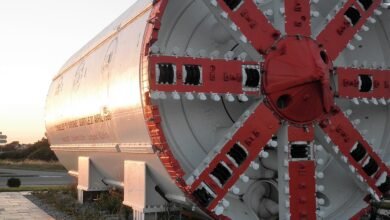
NCC mobilised two Atlas Copco XE3 drill jumbos for the Eysturoy Tunnel, deploying them simultaneously from opposite ends of the alignment to maximise advance rates. Excavation at the Strendur portal began on 21 February 2017; excavation at the Hvitanes portal on Streymoy followed on 27 April 2017. How was the Eysturoy Tunnel built under the Atlantic? Through systematic drill-and-blast cycles executed in competent basalt, supported by pre-excavation grouting, rock bolting, and shotcrete applied at every advance round.
1. Drill-and-Blast Sequence
The drill-and-blast cycle follows a structured sequence. The jumbo advances to the face and drills a pattern of blast holes (typically in a wedge-cut configuration) to a depth matching the planned advance per round. Explosive cartridges are loaded in sequence, with electronic detonators providing millisecond-interval delays that produce a progressive, controlled fracture zone rather than a single shock wave.
After detonation, ventilation fans clear combustion gases and dust from the face before re-entry. Mucking equipment removes the broken rock and loads it onto trucks for disposal at sea. The exposed face then receives immediate support: rock bolts drilled and grouted into competent rock behind the excavation perimeter, followed by steel fibre-reinforced shotcrete applied by wet-mix spray to carry loads until the permanent lining is placed.
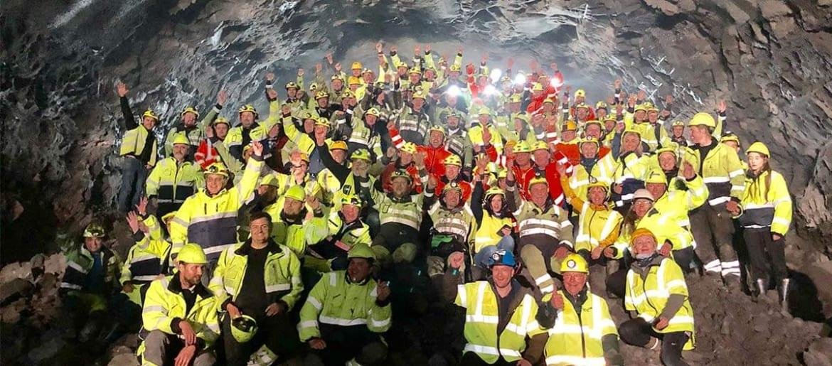
At peak production in spring 2018, the combined advance from both active faces reached 190 metres in a single week. The Strendur heading reached the roundabout cavern on 4 December 2017, after 3,059 combined metres of excavation. With the roundabout and the Strendur arm completed, a third drilling team was mobilised, working the Hvitanes-to-roundabout leg from both ends simultaneously. Those two headings broke through on 7 June 2019 (the last blast of the Eysturoy project), after which NCC transferred equipment to the Sandoyartunnilin.
2. Post-Excavation Works
With excavation complete, the installation phase occupied several months. The drainage system, routing surface water and residual rock seepage away from the carriageway, required kilometres of pipework and multiple pump stations, given the 0.5 percent maximum road gradient. Road surfacing, electrical cabling, lighting, emergency signage, communication systems, and fire-detection infrastructure followed in sequence. The roundabout cavern received its artistic installation in the final construction phase, requiring coordination between NCC’s finishing teams and the commissioned artist’s studio. COVID-19 disruptions pushed the opening from the planned 1 December 2020 to 19 December 2020.
The Eysturoy Tunnel stands in notable contrast to other ambitious subsea tunnel projects in terms of construction philosophy. The Seikan Tunnel in Japan, the world’s deepest mainline rail tunnel at 240 metres below sea level, required over two decades of construction and consumed more than 2,800 tonnes of explosives. Eysturoyartunnilin construction cost and completion date figures reflect a far more compressed programme: four years from first blast to opening, at roughly 1 billion DKK for the Eysturoy component. The efficiency reflects both modern jumbo drill technology and the predictable basalt geology of the Faroe Islands, which, while demanding in terms of grouting, did not present the complex sedimentary and tuff zones that complicated the Seikan alignment.
The Undersea Roundabout: Engineering and Design
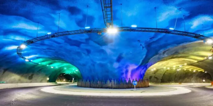
The jellyfish roundabout tunnel junction defines the Eysturoyartunnilin Faroe Islands network and has earned global engineering recognition since it opened. The jellyfish roundabout tunnel sits at 72.6 metres below the North Atlantic, inside a grouted basalt cavern where three tunnel bores converge. The jellyfish roundabout that Faroe Islands motorists navigate has no precedent in subsea road infrastructure anywhere on earth.
The jellyfish roundabout in the Faroe Islands, which motorists navigate at 72.6 metres below sea level, is simultaneously a traffic junction, a structural feature, and a commissioned artwork. The undersea roundabout approved by the Faroe Islands authorities is the feature that distinguishes the Eysturoyartunnilin from every other subsea tunnel ever built, and it warranted specific engineering treatment throughout the construction programme. The jellyfish roundabout in the Faroe Islands tunnel specifications confirm a cavern formed by three converging bores, centred on a retained natural basalt column that serves both structural and artistic functions.
Jellyfish roundabout, Faroe Islands, tunnel specifications confirm the cavern sits at 72.6 metres below the sea surface, formed by three converging tunnel bores at the mouth of Skalafjoerdur. The undersea roundabout approved by the Faroe Islands authorities is the world’s first submerged traffic junction beneath the Atlantic, a feat certified by Guinness World Records in 2020. Understanding how the Eysturoy Tunnel was built under the Atlantic to incorporate this junction requires understanding both the structural role of the retained basalt column and the pre-excavation grouting programme that stabilised the cavern throughout excavation. The world’s first undersea roundabout engineering design resolved traffic, structural, and artistic requirements within a single excavated chamber.
1. Structural Logic of the Junction
A bifurcating junction in a subsea tunnel carries risks that linear alignments do not. Where three bores converge, the rock between them is subjected to redistributed stress concentrations. The central column of basalt left standing inside the roundabout (rather than being removed) carries vertical and lateral loads transferred from the excavated crown above. It was not initially conceived as an artistic feature. It was a structural necessity that the project team subsequently transformed. Artist Trodur Patursson’s installation illuminates that structural column with colour-shifting LEDs and rings its base with an 80-metre steel sculpture of life-size human silhouettes holding hands: the visual identity of the world’s first undersea roundabout engineering design.
2. Artistic Integration and Functional Purpose
The undersea roundabout that residents and visitors of the Faroe Islands navigate serves both as a functional junction and a cultural landmark. Trodur Patursson was commissioned to design the roundabout’s visual identity. The colour palette (deep blue and aquamarine shifting through greens) produces a bioluminescent quality that prompted international media to compare the space to a jellyfish.
Shifting LED sequences cycle through the spectrum, ensuring no two passes through the roundabout are identical. According to EStunlar CEO Teitur Samuelsen, the artwork serves a practical function alongside the aesthetic one: breaking the psychological monotony of a long, dark tunnel and improving driver alertness at the junction. The world’s first undersea roundabout engineering design thus addresses both traffic-engineering requirements and human-factors research simultaneously.
The roundabout also carries operational significance. Drivers approaching from Hvitanes on Streymoy enter the junction and choose between the Strendur exit and the Runavik exit. Without this junction, two separate tunnels would have been required to connect Tórshavn to both eastern-shore destinations, substantially increasing cost and the construction programme. The Eysturoy Tunnel subsea road infrastructure, which Faroe Islands passengers and freight operators rely on, is therefore more network-efficient than any single-bore alignment could be.
Table 2: Undersea Roundabout Key Specifications
| Parameter | Specification |
| Depth below the sea surface | 72.6 m (238 ft) |
| Location beneath | Mouth of Skalafjoerdur fjord, Faroe Islands |
| Central structural feature | Retained natural basalt column (load-bearing and artistic centrepiece) |
| Commissioned artwork | LED colour installation by Trodur Patursson |
| Steel sculpture | 80-metre ring of life-size human silhouettes in stainless steel |
| Traffic function | 3-way junction: Hvitanes (Streymoy), Strendur (west Eysturoy), Runavik (east Eysturoy) |
| World record | First undersea roundabout (Guinness World Records, 2020) |
| Audio feature | FM radio broadcast at 97.0 MHz inside the tunnel |
| Grouting | Systematic full-perimeter pre-excavation grouting throughout cavern construction |
Connectivity, Economic Impact, and Regional Development
The Eysturoy Tunnel’s impact on Faroese connectivity extends beyond journey-time figures. For engineers and infrastructure economists, the more instructive metric is network effect: how the three-branch structure multiplies the value of each connection. A single-bore tunnel between Hvitanes and Runavik would have improved one corridor. The Y-shaped Eysturoyartunnilin improves three corridors simultaneously, connects the two banks of Skalafjoerdur directly, and integrates those connections into a single toll infrastructure, ventilation system, and maintenance regime.
1. Journey-Time Transformation
The before-and-after comparison is clear. Torshavn to Runavik previously required 55 kilometres of mountain road and 64 minutes of driving. The Eysturoy Tunnel reduces that to 17 kilometres and 16 minutes. Torshavn to Klaksvik fell from approximately 68 minutes to 35 minutes. Travel between Strendur and Runavik contracted from a 25-kilometre circuit to a 5-kilometre Eysturoy Tunnel subsea road infrastructure passage.
These compressions do not merely save time; they integrate labour markets, enable access to healthcare and education, and create conditions for residential and commercial development that ferry-dependent communities cannot sustain. The Fehmarnbelt Tunnel between Denmark and Germany, currently under construction as Europe’s largest immersed tunnel project, is similarly expected to redraw economic geographies across the Oresund region when it opens. The principle holds across scales: fixed subsea links create economic integration that no ferry service can replicate.
2. Tourism and Cultural Visibility
The jellyfish roundabout in the Faroe Islands that visitors encounter underground became a genuine tourist attraction from the day the tunnel opened. Visit Faroe Islands confirmed that many drivers circle the roundabout multiple times to absorb the installation, a behaviour widely documented on social media. International media coverage from the BBC, CNN, The B1M, and others generated tourism visibility that no advertising budget could have replicated. The Faroe Islands gained an infrastructure landmark in a different category from conventional road engineering: a submerged public art space accessible by private vehicle, 189 metres below the North Atlantic, serving a jurisdiction of 54,000 people.
3. Per-Capita Infrastructure Investment
The investment scale demands context. The combined contract for the Eysturoy and Sandoy tunnels is 2,073 million DKK, with overall costs for both estimated at approximately 2,600 million DKK. Eysturoyartunnilin construction cost and completion date data position the Eysturoy component at roughly 1 billion DKK, with a population of 54,000. Per-capita investment substantially exceeds comparable European tunnel projects. The Faroese government’s commitment to sustaining that investment through a public company, cross-subsidised tolls, and unanimous parliamentary support reflects an infrastructure philosophy in which connectivity is foundational to social cohesion, not merely a transport efficiency metric.
Technical Performance, Safety Systems, and Operational Standards
The Eysturoy Tunnel operates under Norwegian subsea road tunnel safety standards, the most demanding regulatory framework for this tunnel type globally. The submerged traffic junction Atlantic engineers built here requires continuous drainage, emergency response capability, and ventilation capacity across a network that branches into three separate portal locations, each subject to different surface weather conditions simultaneously.
1. Drainage and Water Management
At 189 metres below sea level, the Eysturoy Tunnel’s drainage infrastructure is critical to safe operation. The 0.5 percent maximum road gradient (shallow by tunnel standards) means gravity drainage alone is insufficient to clear water from the deepest sections. Pump stations with 160-metre water columns at the low points handle rainwater entering through the portals and any residual seepage through the grouted rock. Under the carriageway, an advanced network of channels and pipes keeps road surfaces clear and protects electrical installations from water exposure. The system was designed and installed during the post-excavation finishing phase, with pump capacities sized at 1,200 and 1,500 litres per minute to withstand worst-case North Atlantic storm ingress scenarios.
2. Ventilation and Emergency Systems
Bidirectional tunnels without intermediate emergency shafts pose specific ventilation engineering challenges. The Eysturoy Tunnel uses a longitudinal ventilation system with jet fans that can control airflow direction, enabling smoke extraction toward either portal in the event of a fire. Emergency lay-bys at regular intervals provide safe-stopping zones. Fire detection, CCTV, emergency phones, and public address systems operate from a central control facility. The tunnel also broadcasts an FM radio signal at 97.0 MHz, providing audio continuity for drivers and a communications channel in emergencies. Eysturoy Tunnel subsea road infrastructure: the Faroe Islands’ safety teams continuously maintain these systems, given the tunnel’s critical role in the islands’ road network.
3. Toll and Traffic Management
Electronic toll collection operates through automatic number-plate recognition cameras at each portal. Drivers without registered accounts pay online within three days at tunnil.fo. The toll structure is fixed at a level that cross-subsidises the Sandoyartunnilin and will not decrease until both tunnels’ construction investments are recovered. At 6,386 vehicles per day in 2025, the Eysturoy Tunnel comfortably exceeds the traffic volumes required to meet revenue targets, validating the demand projections that underpinned the entire EStunlar financing model.
Conclusion: The Eysturoy Tunnel Engineering Ambition at Atlantic Depth
Three facts define what the Eysturoy Tunnel actually accomplished. First, it solved a connectivity problem that ferry services and mountain roads had failed to resolve for 54,000 people living across 18 volcanic islands in the North Atlantic. Second, it did so through drill-and-blast excavation in basalt bedrock to a depth of 189 metres, consuming 7,500 tonnes of grout and delivering a three-branch network in four years at approximately 1 billion DKK.
Third, and most consequentially for the global tunnelling industry, it built the world’s first subsea roundabout not as an afterthought but as the structural and operational core of the entire network: a Y-junction cavern that no prior subsea road tunnel had attempted, stabilised, lined, and then transformed by Tróndur Patursson into a bioluminescent public space 72.6 metres beneath the fjord. These are not incidental achievements. They reflect a procurement model, a geological response, and a design ambition that all arrived at the same answer simultaneously.
The precedent matters beyond the Faroe Islands. Every future bifurcating subsea road network will reference the Eysturoyartunnilin’s junction engineering: the decision to retain the basalt column, the systematic grouting programme that stabilised the cavern, and the operational logic of a single tolled junction serving three corridors simultaneously.
The immersed-tube Fehmarnbelt Tunnel crossing the Baltic and the rail corridor through the Seikan Tunnel represent different answers to the same question of how fixed links should serve populations separated by water. The Eysturoy Tunnel’s answer was the most architecturally inventive: a branching network, a retained structural column, a commissioned artist, and a toll model that finances infrastructure the market alone would never have funded. That combination produced the world’s first undersea roundabout and, more practically, a road network that functions as the economic spine of the Faroe Islands’ two most populous islands.
Explore More Tunnel and Underground Engineering Projects
The Eysturoy Tunnel showcases how innovative tunnel engineering can overcome extreme geography and redefine connectivity. Explore more record-breaking tunnels, underground infrastructure projects, and engineering breakthroughs from around the world with Construction Frontier: Global Mega Projects.